
After some more above average temperatures, the trend looks to continue into the weekend. Don't get too comfortable though, as a big cool down looks to be coming next week.
Tonight: Expect mostly clear conditions with a low around 54°. Winds will continue to come out of the south around 5-10 mph.

Tomorrow: Tomorrow looks beautiful for homecoming! Temperatures will be in the lower 60's at the time of the parade and increasing to the mid-70's by mid-day. Overall, expect clear conditions with some passing clouds likely in the afternoon.

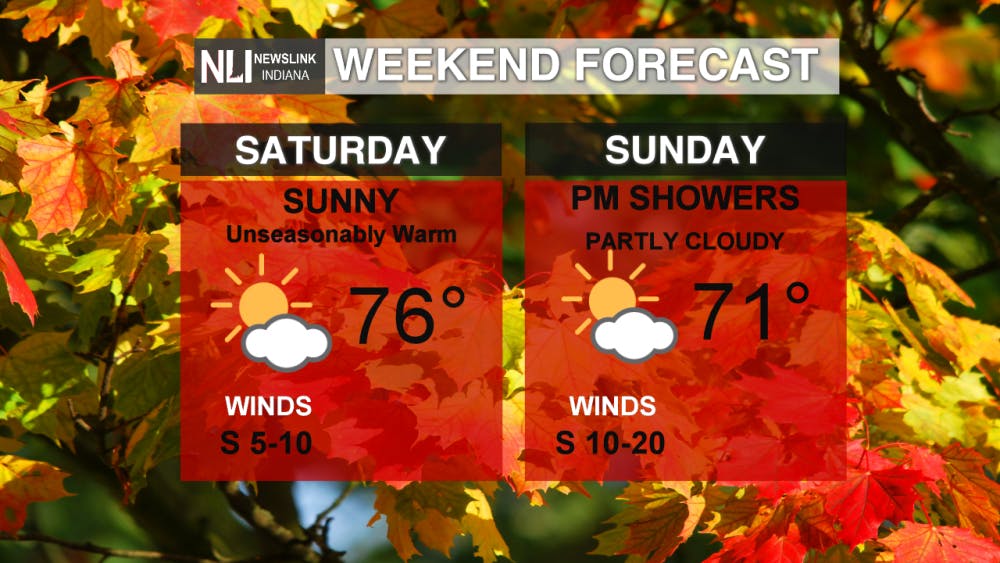
Weekend: The weekend as a whole looks good! Unseasonably warm temperatures look to continue into both Saturday and Sunday. Sunday will bring increasing clouds as well as gustier winds, which could reach 10-20 mph. Some rain showers are possible Sunday night.
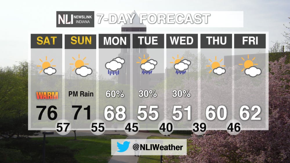
7-Day Forecast: Our sunny skies and warm temperatures look to come to an end next week! After a warm weekend, rain will arrive to the area on Monday, bringing with it lower temperature. We're in for a shock on Tuesday, with a high of only 55°! Lows in the later part of the week could even reach the upper 30's. It's definitely starting to look like fall!
For all your weather needs be sure to follow us on Twitter at @NLIWeather.
--Weather Forecaster Gabe Prough
Read More

Missed It? We’ve Got You Covered - CommCenter Catch-Up
By Ball State Daily / 2 hours agoWith summer internships ramping up, hanging out with friends and family, and making sure you have enough time for yourself – it’s easy to miss Ball State’s Communication Center announcements! This week’s catch-up highlights free Premium Google AI for students, free planetarium shows for June and July, and 2025 U.S. News “Best Online Programs” announced.

9-1-1 What's Your Hot Take E11: Season Ranking
By Willow Emig and Sam Jasionowski / 2 hours agoIn this episode of 9-1-1 What’s Your Hot Take, Sam and Willow rank the seasons of 9-1-1 from their favorite to least favorite.
Nurse practitioner offers three easy ways to save more money in healthcare
By Nick Roark / 7 hours agoSeven out of ten Americans believe the healthcare system is in crisis or has major problems, according to a November 2024 Gallup poll on American healthcare.
