
Today will be chilly, with sunny skies at times. Cloud cover will increase in the afternoon hours, but we clear out by the evening. High of 36°. Winds will be nice and slow today, SW 5-10 mph. We start to see a pattern change overnight tonight, bringing us a brief warmup only to drop us back to cold temperatures. Temperature rollercoaster incoming.
Tonight: After the skies clear out in the evening, skies remain clear Thursday Night. Clouds move back into the area late overnight. Past 3 AM is when we can expect to see the clouds start to meander into the area. Overnight lows don't drop too far from our highs. Low of 25°.
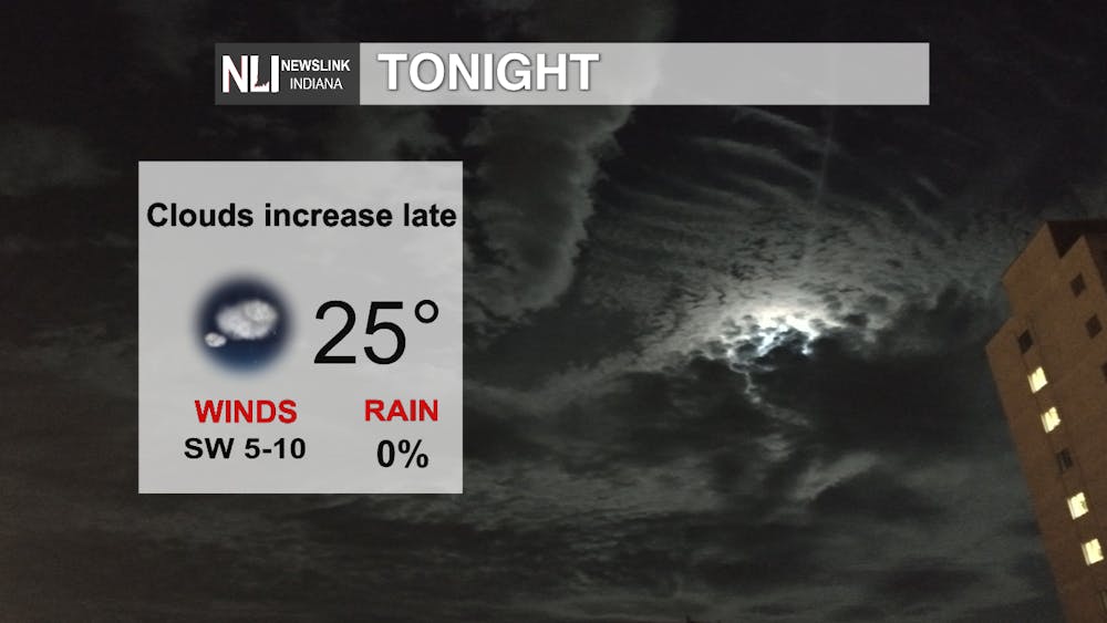
Photo Provided By the NewsLink Indiana Weather Team
Tomorrow: Clouds remain in the area with scattered shower chances in the afternoon thanks to a cold front. We warm up to 50° for our high temperature. Our warmest day in the next 7 days. Rain chances increase going into the overnight hours and into Saturday. Overnight lows don't drop very far at all, with 42°.

Photo Provided By the NewsLink Indiana Weather Team
7-Day: A cold front passes through Saturday morning and we see temperatures decrease throughout the day. Scattered rain/snow chances appear possible through Tuesday. Another cold front pushes its wat through Tuesday, where we see temperatures decrease during the day as well. You get a cold front! You get a cold front! Everybody gets a cold front! We clear out Wednesday and Thursday of week, but cool back down into the upper-30s.
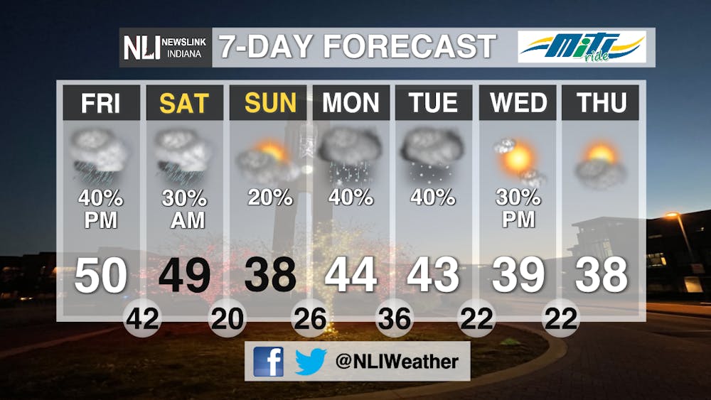
Photo Provided By the NewsLink Indiana Weather Team
--Weather Forecaster Lance Huffman
Follow us on Twitter @NLIWeather for breaking weather updates.
NewsLink Indiana is a proud Ambassador for the NOAA Weather-Ready Nation program. For more information about the Weather-Ready Nation program please click HERE
Read More

9-1-1 What's Your Hot Take E12: Season 6 Recap
By Willow Emig and Sam Jasionowski / 18 hours agoIn this episode of 9-1-1 What’s Your Hot Take, Sam and Willow discuss the events of season 5 of 9-1-1.

Prairie Creek Reservoir beach cleared for reopening
By Staff Reports / 19 hours agoThe City of Muncie announced the reopening of Prairie Creek Reservoir's beach via a press release July 3, successfully passing its water quality tests.

Record Parlor of Muncie aims to create good music and good vibes
By Kylee White / 22 hours agoRecord Parlor of Muncie hopes to provide good music while highlighting local artists.
