
Tonight: Cooler temperatures push into our area for the overnight hours. Most locations will sit in the low to mid 20s across the state. Windchill factors will make temperatures feel more like the teens. Very light snow showers can be expected until 10 pm.
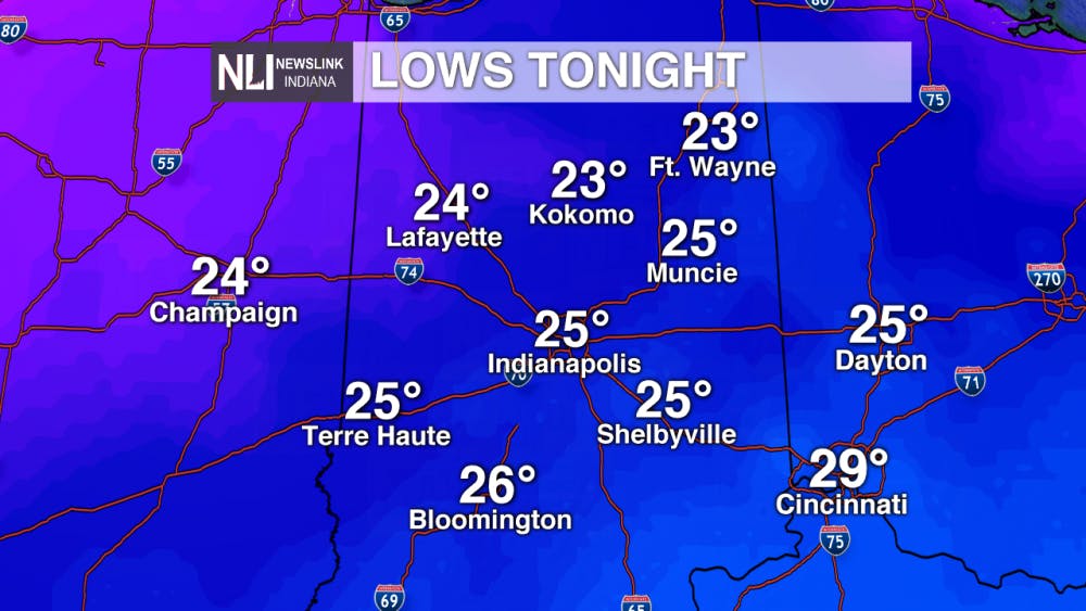
Friday: Highs tomorrow will remain in the lower 40s. Partly cloudy skies will accompany these mild temperatures. Friday is one of the better days to get out and enjoy before very frigid temperatures push into our area.

7-day Forecast: A major shift in our current weather pattern takes place after Sunday. Temperatures cut nearly in half as a blast of Arctic air pushes into our area. The combination of frigid temperatures and moisture in the environment is bringing us our next snowfall on Sunday. Sunday's snow looks to last throughout the duration of the day. If traveling over the weekend, take caution on Sunday.

---Weather Forecaster Liz Szewczyk
Follow us on Twitter @NLIWeather for breaking weather updates.
NewsLink Indiana is a proud Ambassador for the NOAA Weather-Ready Nation program.
For more information about the Weather-Ready Nation program please click HERE
Read More

Tagayi to Represent France at U19 Tournament Before Joining Ball State
By Staff Reports / 18 hours agoBefore making her debut in the Mid-American Conference, incoming Ball State women's basketball player Aniss Tagayi will compete for her home country as part of the French national team in the U19 competition.

IPR: Ball State Village hotel project granted tax abatement for 10 years
By Indiana Public Radio / YesterdayThe new hotel being built next to Ball State University in the Village has been given a tax abatement for the next decade. But as IPR’s Stephanie Wiechmann reports, an agreement with the developer means Muncie coffers will see some money from the project in that time.
Missed the Buzz? Here's Your CommCenter Catch-Up
By Ball State Daily / YesterdayWith the hustle and bustle of summer – from work and classes to chilling by the pool - it’s easy to miss important updates from Ball State’s Communication Center! This week includes a Gatsby – themed dinner program at the E.B. and Bertha C. Ball Center, asphalt paving projects for 2025, and an upcoming change to campus printing software.
