
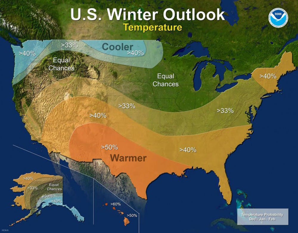
The forecasters at the National Oceanic Atmospheric Administration’s Climate Prediction Center released the U.S. Winter Outlook in October ahead of the upcoming winter season, which is December through February in the Midwest.
Mike Halpert, deputy director of NOAA’s Climate Prediction Center, said the biggest wild card for this winter is the onset of La Niña for the second year in a row.
“Assuming a mild or moderate La Niña, I predict low-to-medium chances of slightly cooler temperatures, particularly for the northern two-thirds of the state. However, given Indiana’s fickle response to La Niña in the past, there’s a reasonable chance that temperatures could be average or even somewhat above average,” said Petra Zimmermann, director of Ball State University’s meteorology and climatology laboratory.
Halpert and NOAA give a 55-to 65-percent chance of La Niña developing before winter sets in for much of the United States.
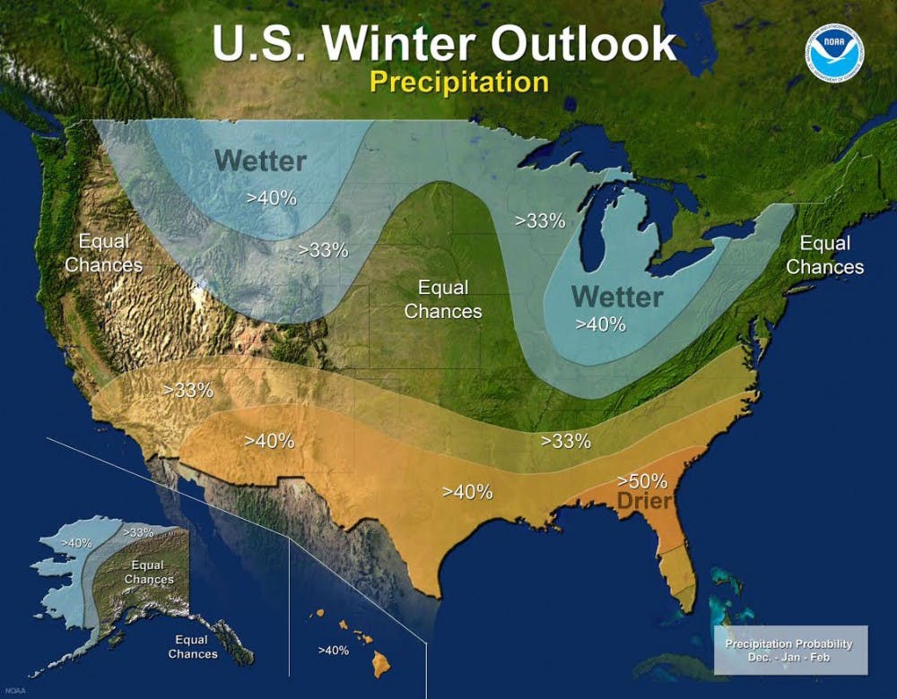
Zimmermann predicts La Niña could bring slightly cooler temperatures and a wetter winter for Indiana.
“The response in Indiana should be more muted than in some other parts of the nation,” Zimmermann said. “Generally, one can expect slightly cooler and wetter winter conditions, but again that depends on the severity of the La Niña.”
La Niña is defined as cooler than normal sea-surface temperatures in the central and eastern equatorial Pacific. La Niña affects the polar jet stream, making it more fluid in movement, which results in more dips and valleys called ridges and troughs. The result is effects to storm tracks and the movement of cold Canadian air to the south toward the U.S.
“Typical La Niña patterns during winter include above average precipitation and colder than average temperatures along the Northern Tier of the U.S. and below normal precipitation and drier conditions across the South.”
Slightly above-average precipitation is certainly possible for Indiana and the upper Midwest. Zimmermann said if cooler temperatures arrive, certainly much of winter precipitation could be in the form of snow.
“The southern half of Indiana will even be more likely to see increased precipitation, though the somewhat warmer conditions farther south might yield more rain or possibly even more ice events," said Zimmermann.
In preparation of the potentially active winter season, the National Weather Service in Indianapolis will conduct a winter weather preparedness campaign Nov. 12-18, to remind residents of winter’s hazards, how to stay safe and educate about preparedness.
Contact Nathan DeYoung with comments at nmdeyoung@bsu.edu.
Read More

Ball State alumna Kayla Davion to speak at the university’s Spring 2025 Commencement
By Gracie Parkhurst / 1 hours agoThe broadway star reflects on her life from Muncie to the mainstage.

The discovery of a beautiful afrofuturist: Octavia E. Butler
By Amira Alquraishy / 20 hours agoAward-winning essayist, journalist, and nonfiction author Lynell George gives us a glimpse into the esteemed writer Octavia E. Butler’s origins of becoming one. Going into her personal confides of her very own journals, we get a crash course into her psyche, and how she overcame the highs and lows of becoming the first African American woman to break into the science fiction genre.

Waltz to resign as national security adviser, becoming Trump’s first Cabinet casualty
By Tribune Content Agency / 22 hours agoMike Waltz, the former Florida congressman who ascended to be President Donald Trump’s national security adviser, is expected to resign, potentially becoming the first Cabinet official to fall in this administration.
