
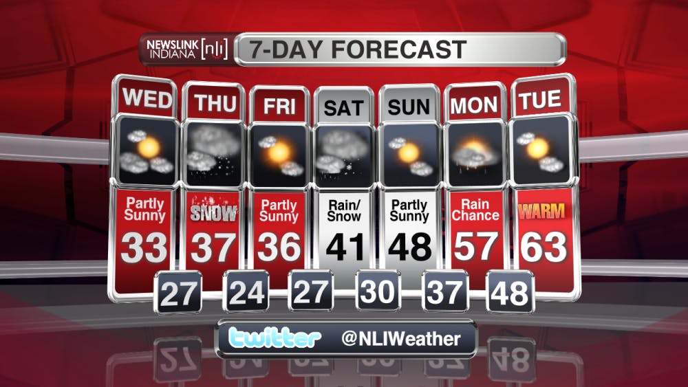
MUNCIE, IN (NewsLink Indiana) -- Our temperatures are taking a massive dive as we head into Tuesday night, with lows bottoming out in the lower 20s. Making things much worse will be the wind chill factor. Winds in the 10 to 20 mph range, with gusts over 20, will create wind chill values in the teens to single digits. The sun will come out for a a period on Wednesday afternoon, before more clouds move in ahead of snow arriving late Wednesday and early Thursday. Snow will continue to fall throughout Thursday morning, likely making for a tricky morning commute. Total accumulations are expected to be in the 1 to 2 inch range as of this time, but the temps will be rising throughout the day on Thursday, eventually leading to a rain/snow mix in the early afternoon, likely causing most of the snow that fell earlier in the day to start to melt. Another snow/rain chance arrives on early Saturday as the temps begin to rise as Ball State starts spring break, with temperatures reaching into the 60s by next Tuesday. For more details on the snow and your spring break weather, be sure to check out the most recent video forecast.
Read More

ICC: Defense letter confirms Indiana’s Camp Atterbury to be used for immigrant detention
By Indiana Capital Chronicle / 5 hours agoIndiana’s Camp Atterbury will be used to detain immigrant detainees under a new federal plan revealed this week by Defense Secretary Pete Hegseth.

ICC: ‘Good trouble’: Hoosiers rally against Trump, honor late US Rep. John Lewis
By Indiana Capital Chronicle / YesterdayHundreds of people rallied outside the Indiana Statehouse on Thursday to protest President Donald Trump and pay tribute to U.S. Rep. John Lewis of Georgia.

IPR: Prairie Creek trails to permanently close to ATVs and horses August 1
By Indiana Public Radio / 2 days agoThe Muncie parks board will permanently close trails on Prairie Creek Reservoir’s west side to ATV and horse riders on August 1 after the closure was requested by the property’s owner, Indiana American Water.
