
UPDATE: Muncie saw right around 4.5 to 5 inches of snow last night, with parts of the region seeing anywhere from just over 2 inches to the north to 7 inches in places such as Randolph county. At the bottom of this article we have included just some of the preliminary snowfall reports as received via NewsLink Indiana Weather in graphical form as well as a complete list as reported by the National Weather Service below.
SNOW REPORTS LISTED BY AMOUNT
7.00” — LYNN, RANDOLPH COUNTY — 0255 PM
6.50” — 2 MI NW STRAUGHN, HENRY COUNTY — 1240 PM
5.50” — ALBANY, DELAWARE COUNTY — 0220 PM
5.50” — UNION CITY, RANDOLPH COUNTY — 1035 AM
5.50” — WINCHESTER, RANDOLPH COUNTY — 0854 AM
5.50” — 2 MI SW NEW CASTLE, HENRY COUNTY — 0700 AM
5.00” — N ANDERSON, MADISON COUNTY — 0200 PM
5.00” — DALEVILLE, DELAWARE COUNTY — 1159 AM
5.00” — KNIGHTSTOWN, HENRY COUNTY — 1010 AM
5.00” — ANDERSON, MADISON COUNTY — 0853 AM
5.00” — MUNCIE, DELAWARE COUNTY — 0850” AM
4.50” — MUNCIE, DELAWARE COUNTY — 0853 AM
4.50” — 3 MI NNE FARMLAND, RANDOLPH COUNTY — 0700 AM
4.40” — ANDERSON, MADISON COUNTY — 1015 AM
4.00” — 3 MI S ALBANY, DELAWARE COUNTY — 0700 AM
3.90” — 4 MI N ANDERSON, MADISON COUNTY — 0732 AM
3.80” — 2 MI N MUNCIE, DELAWARE COUNTY — 0650 AM
3.70” — 1 MI NNW YORKTOWN, DELAWARE COUNTY — 0600 AM
3.60” — 3 MI W NEW CASTLE, HENRY COUNTY — 0700 AM
3.50” — 1 MI NE FAIRMOUNT, GRANT COUNTY — 0121 PM
3.00” — SELMA, DELAWARE COUNTY — 0809 AM
3.00” — UNION CITY, RANDOLPH COUNTY — 0737 AM
2.60” — 2 MI NNW MILL GROVE, BLACKFORD COUNTY — 0800 AM
2.50” — 8 MI SE MUNCIE, DELAWARE COUNTY — 0541 AM
2.50” — 4 MI SSW ROLL, BLACKFORD COUNTY — 1118 AM
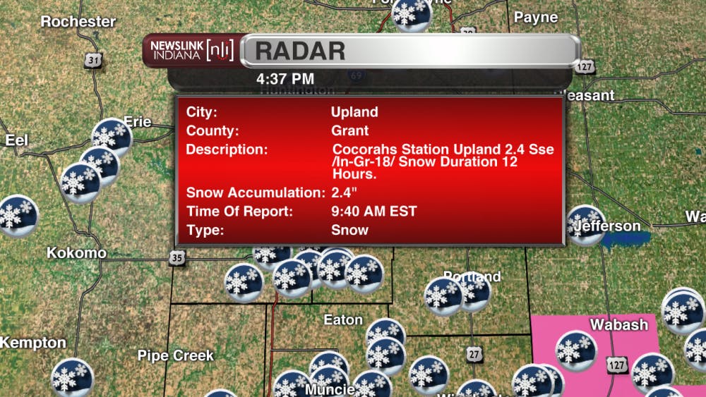
2.40” — 2 MI SSE UPLAND, GRANT COUNTY — 0940 AM
2.00” — 3 MI E GAS CITY, GRANT COUNTY — 1035 AM
2.00” — 3 MI ESE UPLAND, GRANT COUNTY — 0810 AM
2.00” — 1 MI SSW BLAINE, JAY COUNTY — 0805 AM
2.00” — 1 MI N HARTFORD CITY, BLACKFORD COUNTY — 0805 AM
2.00” — 1 MI SSW COLLEGE CORNER, JAY COUNTY — 0733 AM
1.90” — 1 MI SSE HARTFORD CITY, BLACKFORD COUNTY — 0815 AM
MUNCIE, IN (NewsLink Indiana Weather) – Winter storm warnings fly as the next round of winter weather arrives tonight and lasts through Saturday. A Winter Storm Warning is in effect for Delaware, Henry, Madison, and Randolph counties until 7pm on Saturday (No longer active, cancelled early.) and a Winter Weather Advisory will be in effect for Blackford, Grant, and Jay counties from 1am Saturday until 7pm Saturday (No longer active, cancelled early.) Snow will start to fall in the evening/overnight hours of Friday through Saturday evening. Total storm accumulations in Muncie are expected to be between 3″ to 7″. Areas to the south could see snowfall totals closer to 8″ with the counties to the north only receiving 2″ to 5″. The model comparison at the bottom of this page shows all the possibilities the current models are predicting.
During the day on Saturday we could also see some mixing of sleet or freezing rain in with the snow as temps will rise to a high of 33 Saturday afternoon. At this time analysis is showing sufficient cold air aloft to support snowfall throughout Saturday, but with the warming surface layer, a wintry mix may still be possible. The NewsLink Indiana Precisioncast slides attached show the snows progression as it moves through tonight and into Saturday. A break sets up in the morning hours, however things pick back up by noon before tapering off through the afternoon on Saturday. Take extra care while traveling this evening and through Saturday. Make sure to allow extra time to get to your destinations, and make sure you have a means to contact help if you become stranded.
Read More

PHOTOS: Muncie holds 46th annual Iron Man Triathlon
By Kylee White / 15 hours agoOn July 12th, Muncie held its 46th annual Iron Man Triathlon at Prairie Creek Reservoir.

Riverside Avenue Closed Due to 'Geothermal Leak' on Ball State's Campus
By Staff Reports / YesterdayConstruction crews were working as of Monday to reopen Riverside Avenue between Warwick and Briar roads due to a geothermal leak.

IPR: Ball State Village hotel project granted tax abatement for 10 years
By Indiana Public Radio / 2 days agoThe new hotel being built next to Ball State University in the Village has been given a tax abatement for the next decade. But as IPR’s Stephanie Wiechmann reports, an agreement with the developer means Muncie coffers will see some money from the project in that time.
