


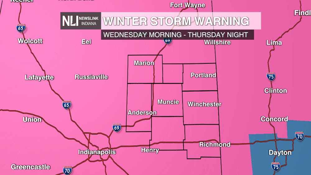
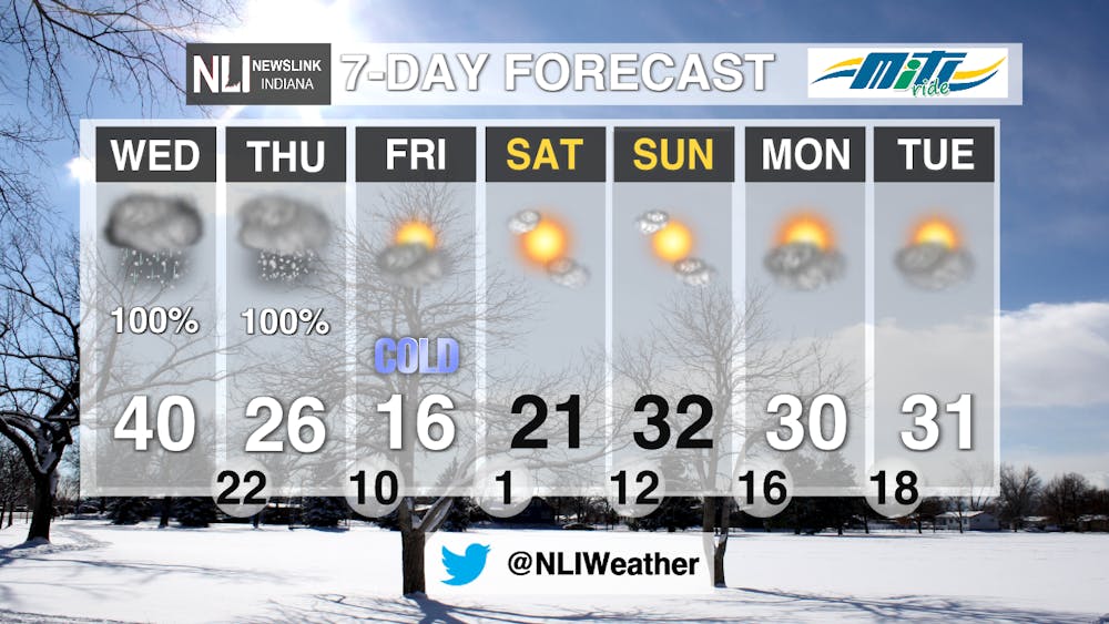
A major, significant winter storm is on the way, expected to last for a duration of 2 days. Our entire viewing area has been upgraded to a WINTER STORM WARNING from Wednesday morning until Thursday night. Rain begins tonight, heavy mixed precipitation will occur on Wednesday, before finally changing over to heavy snow on Thursday. Daily life and travel will be impacted, especially on Thursday. According to the National Weather Service Northern Indiana office, this is a 1 in every 10 years event!
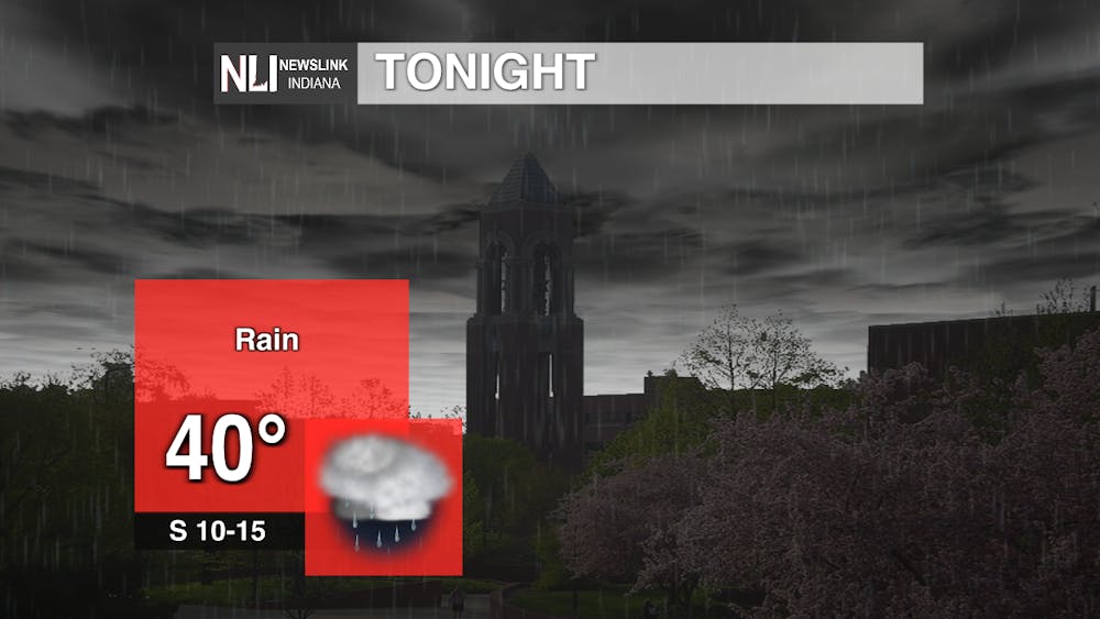
Tonight: Unsettled weather begins with rain, starting around midnight or shortly thereafter. Rain will move in from the southwest and overspread our viewing area. As the result of the placement of a warm front, lows will only drop to near 40 degrees. Winds will be from the south at 10-15 MPH, with gusts up to 25 MPH. Travel impacts will be minimal as precipitation will be all rain through the early morning hours of Wednesday.
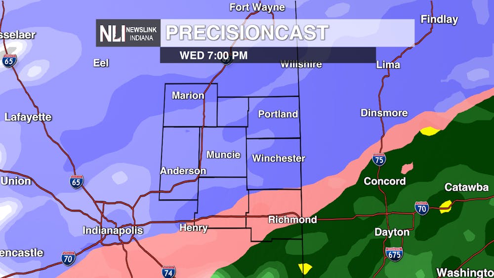
Wednesday and Thursday: A WINTER STORM WARNING has been issued by the National Weather Service for our entire viewing area (and much of the state of Indiana) from Wednesday morning until Thursday night. Significant winter weather is possible, including freezing rain, ice, and heavy snow. Prepare for major travel impacts and disruptions to daily life.
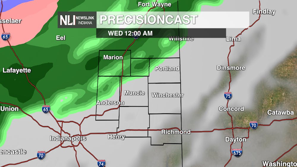
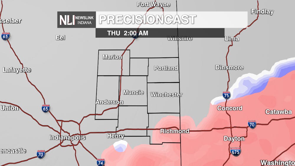
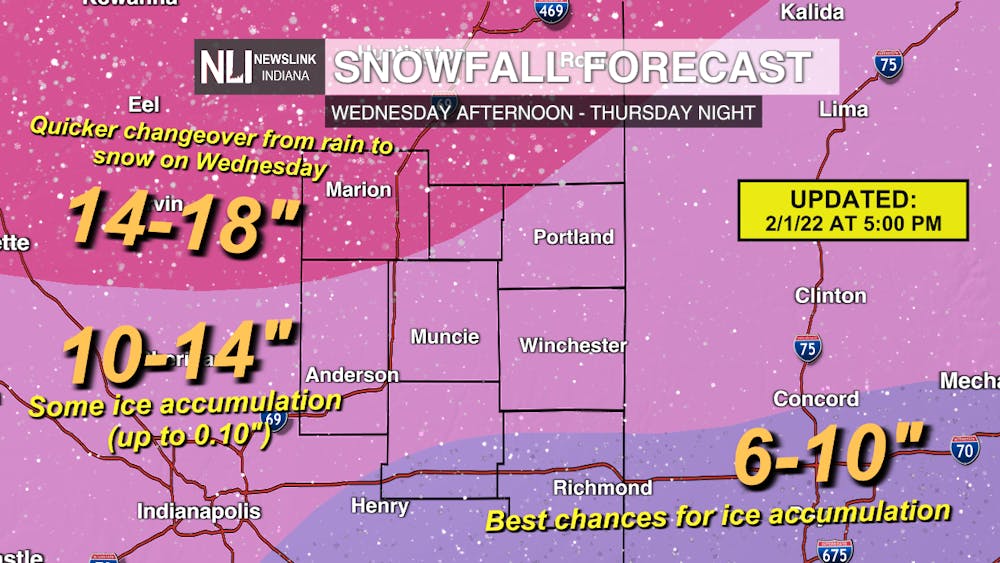
We are initially thinking precipitation will begin as rain late Tuesday into early Wednesday morning. A change to mixed precipitation will occur Wednesday afternoon, becoming all snow across central Indiana by Wednesday night. Heavy snow is possible on Thursday. The changeover from rain to mixed precipitation to snow will happen from northwest to southeast between 2-6 PM Wednesday across Delaware County. If we stay in a period of mixed precipitation for a longer duration, more ice will accumulate. If the changeover happens quickly, little to no ice will accumulate. The greatest chances for ice accumulations will be in Henry and Wayne counties. Any snow we see on Wednesday will be a heavy, dense snow with a high moisture content.
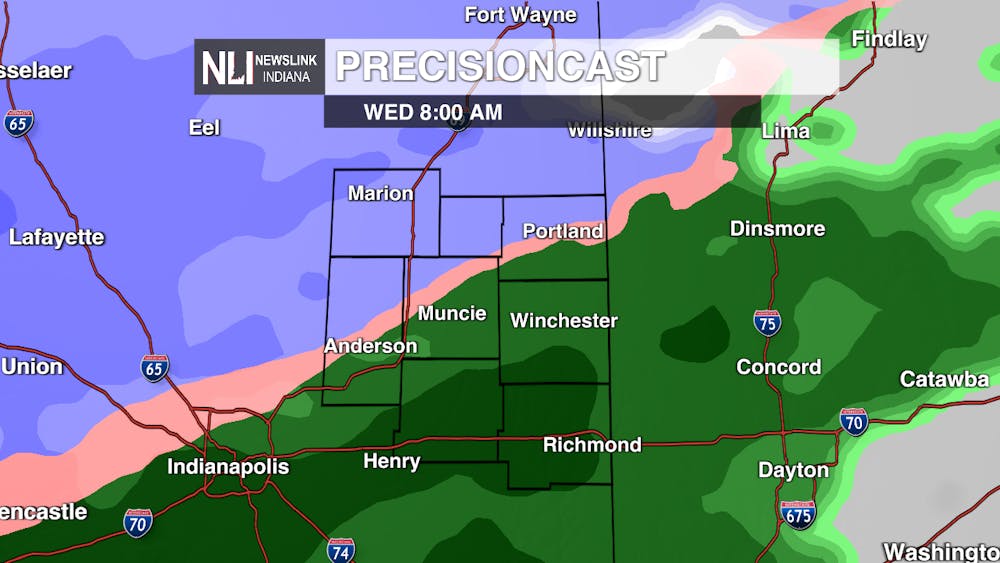
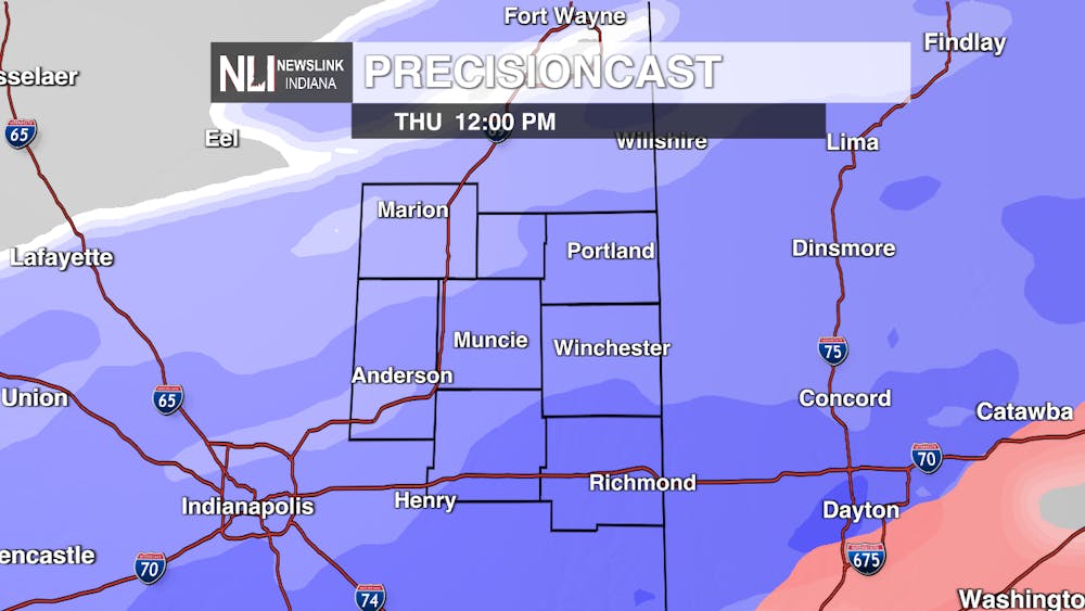
A brief lull in precipitation will be possible overnight before a firehose of snow moves in for the day on Thursday. Between early Thursday morning around 3-4AM and Thursday night by 9 PM, this is when we expect the bulk of the snow to accumulate across northeastern central Indiana. Snowfall rates could be 1-2" per hour at times, with means that the snow will accumulate potentially faster than snow removal crews can get to it. As a result of colder air moving in, the snow on Thursday will be powdery and light, meaning blowing snow is also a concern.
NEWSLINK INDIANA WEATHER TEAM OFFICIAL SNOWFALL FORECAST: By the time all is said and done by Thursday evening, we expect snow totals between 10-14" for Muncie with up to 0.10" of ice accumulation. In our northwestern counties, rain will quickly change over to snow early Wednesday afternoon, so snow totals will be higher in the 14-18" range. Snow totals will be suppressed in our southeastern counties where more mixed precipitation and ice is likely to persist Wednesday evening.
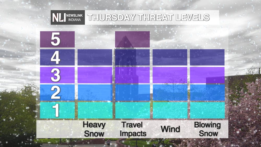
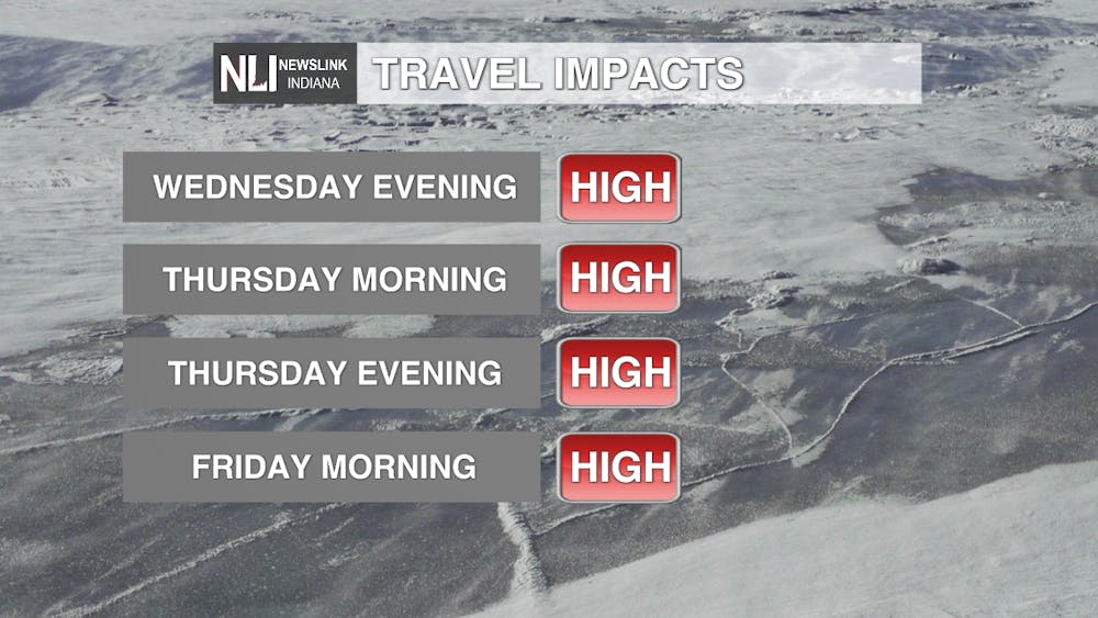
The incoming winter storm will be a significant, impactful, and hazardous event across much of Indiana. Due to ice accumulations, tree damage and power outages are possible on Wednesday as the changeover to snow occurs. All threats are in play on Thursday, with significant impacts likely. Travel is very highly discouraged, with heavy snow, blowing snow, and strong winds making for life-threatening travel. Snow will easily be blown about, which will limit visibilities. Have an emergency kit in your car and a plan in place if you must travel. Travel impacts will be high across the region extending from Wednesday night through Friday morning. Commutes will certainly be impacted during this time frame. STAY HOME, if at all possible; it is not worth risking your safety or life in order to travel if it is non-essential.
7-day Forecast: After the major winter storm, we expect an extended period of dry, cold conditions. Arctic air will rush in on Thursday and carry over into the start of the weekend. Our coldest night of the week will be Friday night, with lows approaching zero. Temperatures moderate into early next week, going back up to near freezing.
Chief Weather Forecaster Maddi Johnson
Follow us on Twitter @NLIWeather for breaking weather updates.
NewsLink Indiana is a proud Ambassador for the NOAA Weather-Ready Nation program.
For more information about the Weather-Ready Nation program please click HERE


