


Tonight: Much of tonight will feel more humid and muggy as Southerly winds continue to bring in more moist air and warmer temperatures. Our dew points from early midday Monday into tonight will remain in the low 60’s, making it feel more humid. The warm temperature/moist air combo creates for a more muggy warm air feeling. Surface winds will be assisted with stronger wind gusts as isobars tighten and a low-pressure system from the West shifts North. Much of tonight’s weather will stay North of us as low pressure remains in Northern Wisconsin/ Northern Michigan. Besides that, much of tonight will remain quiet for our area.
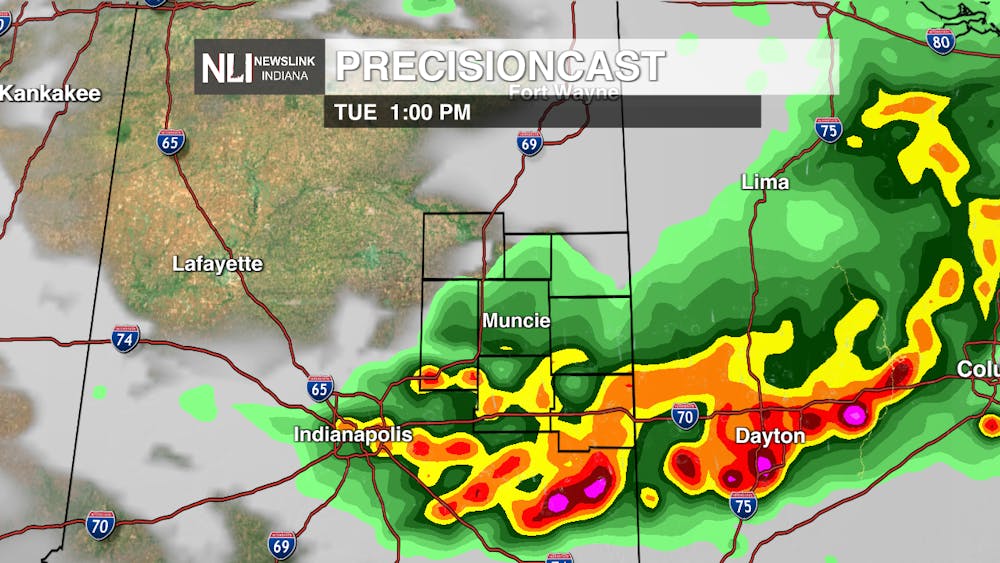
Tomorrow: Most of Tuesday will remain warm and humid with above average temperatures in the afternoon to early evening hours. Towards the afternoon, a small line of storms will come through, then retreat. A lot of the ingredients needed for severe weather will be present tomorrow as we see a surplus in moisture, instability, lift, and wind shear. Strong upper-level jet will increasingly get stronger throughout the day as well as supporting convective development. Muncie is in a level 1/5 (Marginal risk) for severe weather indicating that any of the storms that do form in our area are capable of producing hail, damaging winds, and a possible tornado. But the severe weather threat is higher towards Northwestern Indiana as a frontal boundary from up North moves in. Northern Indiana is in a level 2/5 for severe weather (Slight risk) with higher confidence in damaging winds, severe hail and even a tornado touchdown. As of right now, the leading threat from these storms will be damaging winds, but all hazards are still possible. Models show more confidence in severe storms moving through up North. For our area models show more confidence in rain showers and winds into Wednesday morning. No matter what though, always stay weather aware.
Seven-Day Forecast: Rain potential along with a few possible thunderstorms will continue towards the end of the week. Temperatures will remain pretty consistent this week with highs remaining in the high 70’s low 80’s. For Saturday evening, models are in agreement that a strong low pressure tracking North will create a cold frontal boundary pushing a quick line of rain showers and thunderstorms through the area. Temperatures will significantly drop from 70 degrees to 50 degrees. From this cold front will be the return of cooler drier weather for Sunday into next week. Very strong upper-level jet visibly supports this cold front as a deep trough over central US develops. Tightening isobars supports the push for strong winds and storm development. As for the rest of this week, low pressure assisted with another front will continue to make its way closer to our area Wednesday, supporting cloudy development and rain showers. A few possible thunderstorms are likely towards late afternoon/ early evening as Southerly winds continue into our area in support of this. As for Thursday, we should see some spotty showers, but for the most part everything should start to clear out as a frontal boundary moves through transitioning from spotty rain to cloudy skies. Friday looks to be the nicest day of the week as we see a high temperature of 82 degrees as well as some sunny skies.
- Weather Forecaster Rachel Fulton
Follow us on Facebook, Instagram, and X @NLIWeather for breaking weather updates.
NewsLink Indiana is a proud Ambassador for the NOAA Weather-Ready Nation program.
Click here for more information about the Weather-Ready Nation program
