


-Basics of this winter weather system-
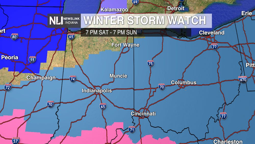
This has been a storm that has gripped the attention of people nationwide. More than 175 million Americans are under some form of winter weather advisories and watches that impact 35 states, according to the National Weather Service. The NWS has placed the entire NewsLink Indiana viewing area under a winter storm watch from 7 p.m. Saturday to 7 p.m. Sunday. Heavy snow is possible during the time period of the watch. The potential impacts on the Muncie area have changed significantly over the past couple days.
This winter weather is relatively new to the forecast because models have shifted within the past week. Previously, the heavy snow was projected farther south in Kentucky and Tennessee. Models began to shift the heavy snow north within the past three days, and it now appears the Ohio River region will receive the heaviest snowfall totals.
Here in Muncie, snow moves in Saturday evening with the worst happening all day Sunday. Snowfall rates will slow down into the evening before moving out Monday morning.
-Negative wind chills through the weekend-
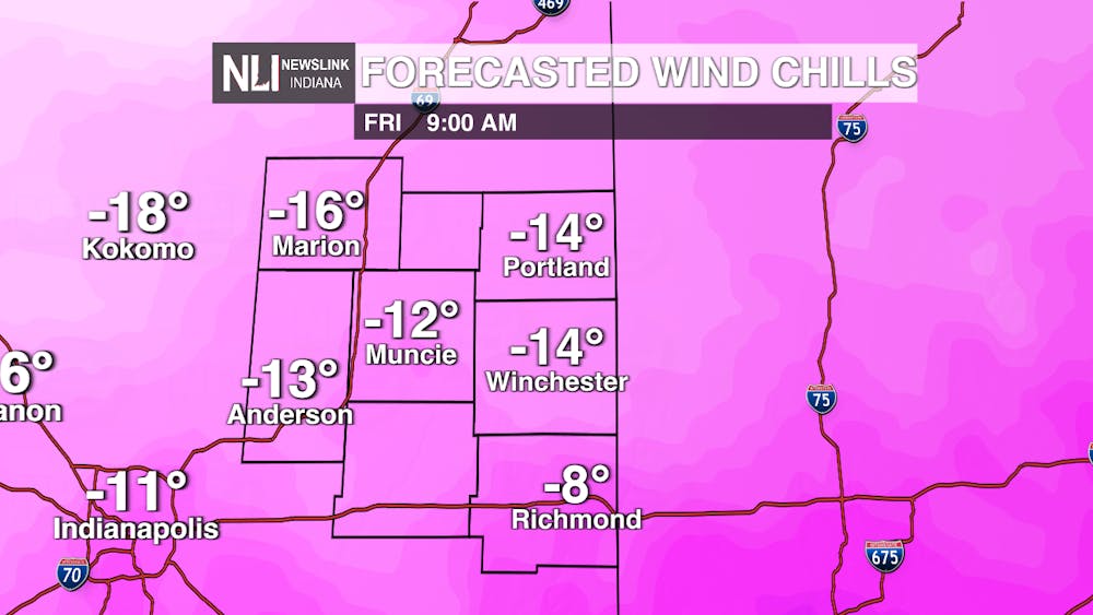
Before the snow moves in, we will deal with dangerously cold wind chills throughout the weekend. Temperatures fall off drastically tonight, falling into low single digits. Paired with wind gusts of 25-30 mph, wind chill values will be bitter cold on Friday morning with values in the negative double digits expected. These negative wind chills last the entire weekend through the worst of the snow.
Under these conditions, frostbite can develop in under 30 minutes according to the NWS Wind Chill Index. If you have to go outside this weekend, wear layers to prevent frostbite. Temperatures will be dangerously cold, so this is the weekend to stay inside out of the cold.
-How much snow will we get?-
This is the question that everybody wants to know. As a disclaimer, projected amounts will change as models update throughout the next couple days. However, weather models have started to come into agreement overnight about snow totals and a range can be given at this time.
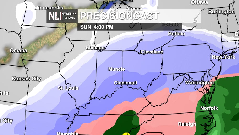
As of this evening, Muncie is projected to get between 7-9 inches of snow over the weekend, with double digit amounts very possible. This number is very much in flux and can change over the next couple days. Heavy snow will last throughout Sunday and into early Monday. Regardless of final totals, travel Sunday and Monday morning is likely to be very difficult. Make sure you leave yourself plenty of time to get to your destination.
Models have pushed the heavy snow north to the point that we will face some of the heavier totals. Here is how the forecast can change:
-If models continue on this path, we can easily receive double digit snowfall totals.
-If models remain the same, we will likely see the 7-9 inch snowfall forecast in place at this time.
-If models reverse and begin to push the heavy snow south, we will see less snow as a result.
Ultimately, we are set up for a dangerous winter system that will bring plenty of cold temperatures and heavy snow. Ensure you have a plan in place and are stocked on supplies over the weekend. If you need to go outside, take precaution against these harsh winter conditions.
-A note on exploding trees-
One of the popular topics of conversation going around right now is the threat that temperatures will drop so low that trees will explode! Take comfort knowing that temperatures here, for as low as they will be, will not be cold enough for this to happen. The chance of this will be concentrated in northern Midwest states like Minnesota and North Dakota.
In cases where this does happen, the trees will bulge out rather than actually explode like dynamite. This is because the water and sap in the trees freezes and expands due to brutal, cold temperatures. Once again, this is not a concern here in east central Indiana.
Make sure to stay tuned to the Cardinal Media BSU website for further weather updates, and stay warm this weekend.
-Chief Weather Forecaster Joseph Sawicki
Follow us on Twitter @NLIWeather for breaking weather updates.
NewsLink Indiana is a proud Ambassador for the NOAA Weather-Ready Nation program.
For more information about the Weather-Ready Nation program please click HERE


