
Meteorological fall refers to the months of September, October, and November. Meteorologists use the term "meteorological fall" in reference to the annual temperature cycles. Astronomical fall is what most people are used to and that is based off of Earth's position to the sun (this year: September 23rd - December 21st).
Temperature:
Fall is what most meteorologists term a "transitional season." With a constantly moving jet stream and less daylight, many cold and warm air masses are battling each other, which is why there are so many temperature swings. The shorter amounts of sunlight explain why there is such a large diurnal (daily) temperature variation.
September starts the stretch of the transitional season. To put it in perspective, the average high temperature on September 1st is 83 degrees and by the end of the month, September 30th, the average high temperature is 9 degrees cooler at 74-degrees! The length of daylight plays a key role in warming things up! This September started off on a hot streak with 3 90+ degree days within the first week. After the hot start, temperatures quickly dropped back to normal (~75-80 degrees) and never neared the 90-degree mark for the rest of the month. The average temperature was just 0.5 degrees warmer than normal, despite the relatively cool days in the middle of the month.
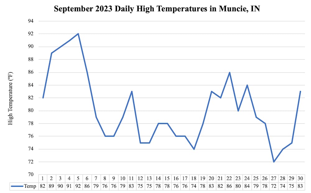
The transitional season is when the hot temperatures start to retreat, though Muncie saw 19 days of 80+ degrees for highs, with 10 of those days reaching 85-degrees or hotter!
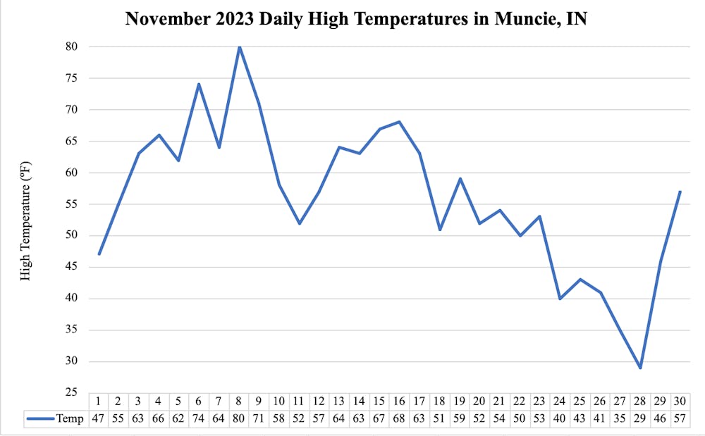
Cold temperatures continued into the start of November, but things quickly warmed up by the 8th when the warmest day of the month was recorded with a high of 80 degrees. This, likely being the last 80 degree day of 2023. A cold front passed through the area and 3 days later, highs were nearly 30 degrees cooler! Temperatures then moderated in the 50s and 60s for majority of the month before the coldest air of the season arrived late. A brisk 29 degree high was reached on the 28th with blusterly winds as well, making for the wind chill to be in the single digits. The frigid end was the only time temperatures got well below normal. For the month, the average temperature sat 1.3 degrees above average.
Precipitation:
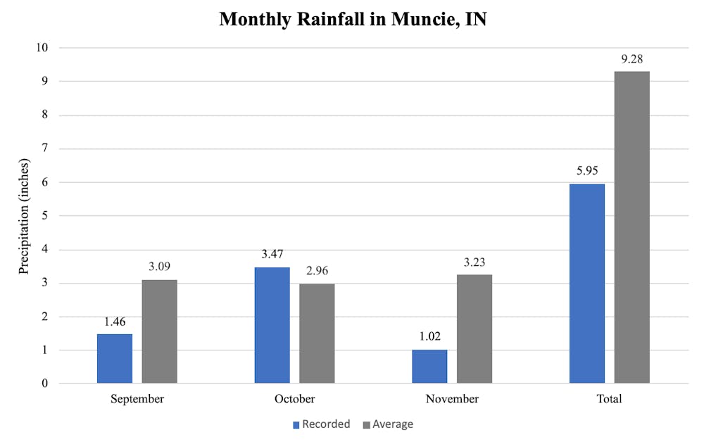
The dry spell from the summer continued into September. High pressure dominated for most of the month and for the first 25 days of the month, only 0.41" of rain was recorded! This was the 5th driest stretch for this period on record. With this, 93% of the state fell under moderately dry conditions, although, a nice soaking rain fell on the 27th which replenished some of the drought.
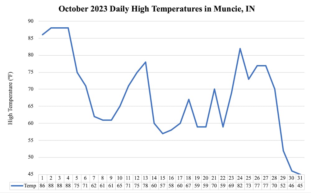
October brought several days of rainfall, accumulating to 3.46" which was the 3rd wettest month of this year! October would also bring the first flakes of the season. The first flakes fell on the 30th, though the larger band of flakes fell on Halloween. This would be the only month this season with above average precipitation.
With colder temperatures and less daylight, comes more cloud cover. November is typically the 3rd cloudiest month of the year, with only 41% of possible sunshine. This November was one of the more sunnier November's on record as 71% of sunshine was seen. Due to the abundance of sunshine, no measurable rainfall was documented until the 17th when 0.59" of rain fell. Rainy days were sparse throughout the month and November was yet another month of below average precipitation, as just over an inch of rain was reached. Putting it to the record books, this was the 5th driest November on record.
More archived climatological data for Muncie, Indiana can be found here.
-----
Follow us on Facebook, Twitter, and Instagram @NLIWeather for breaking weather updates.
NewsLink Indiana is a proud Ambassador for the NOAA Weather-Ready Nation program.
For more information about the Weather-Ready Nation program please click HERE
Read More

Ball State ends 2025 season with loss to Miami in MAC Softball Championship semifinal
By Zach Carter / 10 hours agoBall State ended the year with a 8-0 loss to Miami.
Cardinals elect a new pope, the first American pope in history
By Staff Reports / 2 days agoCardinal Robert Prevost, an American missionary who spent his career ministering in Peru and leads the Vatican’s powerful office of bishops, was elected the first American pope in the 2,000-year history of the Catholic Church, according to the Associated Press (AP).
'A blue-collar team:' Ball State run rules Akron in opening game of MAC Softball Championship
By Zach Carter / 3 days agoNo. 4 Ball State topped No. 5 Akron 9-1 in the Cardinals' first game of the Mid-American Conference Softball Championship Wednesday afternoon.
