


October has always been a major transitioning month going from the warm temperatures of summer to the cooler temperatures of late fall or early winter, this month was no exception, starting off the month in short weather with highs reaching the upper 80’s and ending in the first taste of winter weather on Halloween with highs only reaching the low 40’s with the autumn’s first frost advisory. Major temperatures fluctuations were not the only thing October brought, Muncie seen more rain, in the month of October, then it has seen in the last 3 months. If you were to look up in the sky on any given day the chances are that the sky would appear partly cloudy with the sun shining and the average windspeed around 7 mph.
Temperature
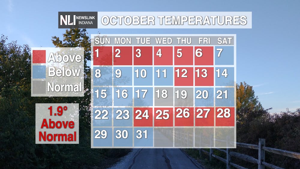
October is considered a transitional month which means it falls in the transitional period of Autumn. In result temperatures tend to vary more significantly from week to week rather than staying inside a certain range of temperatures. This month temperatures started off with temperatures peaking in the upper 80’s with the monthly high peaking at 88 degrees on the 2nd and the 3rd. For the first week an average temperature of 67 degrees was recorded with the high again being 88 degrees for the week and the low recorded at 41 degrees on the 7th. During the following week temperatures fell significantly more with the average high only up to 55 degrees, already 10 degrees cooler than the previous week, with a recorded high of 78 degrees and low of 50 degrees. Temperatures continued this pattern throughout week three with a high of 70 degrees on the 21st and a low of 40 degrees occurring that night, the average temperature for the week was 54 degrees.
However, while we were experiencing record highs the Great Plains region of the United States was experiencing record lows due to a massive anomaly in the polar Jetstream. This would bring large, dry, polar airmass into the central United States which would push warm tropical air masses up into the Southeast and Midwest during Week 4 bringing a significant heatwave through the area with record setting temperature for that time of year peaking at an astonishing 82 degrees on October 24th and cooling off to a chilly 32 degrees the night before, the average temperature for the week was 69 degrees, two degrees warmer on average then when the month started..
The final week of October was the aftermath of the Jetstream anomaly as it sweeps East plummeting temperatures to the first observed lows below freezing of the season with temperatures dropping nearly 20 degrees overnight. The high for the week would only come to 52 degrees, 30 degrees colder than the pervious week! The low for the week would also follow suit plummeting to a freezing 25 degrees; dropping the average high for the last 3 days of the month to 40 degrees, a whopping 27 degrees below the average temperature at the beginning of the month.
Weather
October would see several days of rain throughout the month with the most falling on the 13th with 0.84 inches of rainfall spanning throughout the day. In total 3.47 inches of water fell from the sky this month making it the 3rd wettest month this year, behind July, 5.26 inches, and March, 6.95 inches. Flurries flew for the first time this month as well, on the 30th light flakes fell overnight before a line of large flakes fell the next day. However, there was no accumulation due to the ground not being frozen yet. October would also see 13 days of haze or fog, 5 days less than last month. The sky remained mostly clear for the whole month with clouds circulating here or there, with the average day looking partly cloudy with a chance of early morning fog.
Winds tended to be more out of the south to southwest during the weeks of warm temperatures, like week 1 and week 4. For weeks with temperatures below the average monthly temperature winds generally came from the northwest. The northwest winds tended to be stronger averaging around 7.4 mph. Unfortunately, strong northwestern winds tend to be primarily associated with cold fronts and generally more cloud cover, giving us those first cold Autumn days this month. The southwestern winds, however, were weaker, averaging around 6 mph for the month.
Summary
October is known for its rollercoaster temperatures with the average weekly high dropping 27 degrees from the start to the month to the end. The month average came out to 59.1 degrees, making it the second hottest October in the last 5 years, only being topped by 2021 where the monthly average was 60.9 degrees Fahrenheit. October also saw a good amount of rain, after being in a moderate drought for most of September, fortunately October saw enough rain to bring us out of the drought. All in all, this October brought us those last few tastes of summer before we begin our journey into winter.


