
Tonight: Although conditions were calm for a short time, more rain showers continue to move across the East Central Indiana this evening. Overcast conditions will set after the rain showers move out. Tonight, temperatures will drop down to 52 degrees remaining mild. New rain accumulation amounts of .25" or less are expected.

Tuesday: Despite the early morning rain showers that are possible, conditions will remain mild again for the second day in a row. Overcast skies will accompany high temperatures near 59 degrees in Muncie. Winds throughout the day will shift to the WNW from 5-10 mph as the cold front passes through. A tad cooler air is behind the front, but conditions will rebound before the next low pressure and cold front pulls through Wednesday and Thursday.

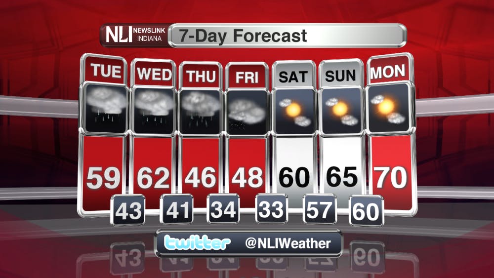
7-Day Forecast: Buckle you seat belts for another week of wild weather in Indiana. A wet and soggy start to the week will give way to cooler temperatures before rebounding to a mild weekend. The rain chances will remain in the forecast until Thursday afternoon as the last system pushes through Indiana. A few snow flurries are possible late Thursday evening into the early morning hours on Friday. No snow accumulation is expected at this time. A early look into the weekend show temperatures to mild and above average.

--Weather Forecaster Nathan DeYoung
Read More

IPR: Gov. Mike Braun says tolling needs to be an option for Indiana’s road funding future
By Indiana Public Radio / 17 hours agoGov. Mike Braun was given slightly more expansive authority this year to explore tolling Indiana’s interstate highways.

Mental health care and facilities are almost non-existent in rural communities
By Trinity Rea / YesterdayFor a large number of Indiana’s rural residents, access to specialty care — specifically that for psychiatry and mental health — is a struggle.
Ball State adjusts 51 degree programs amid statewide enrollment mandate
By Trinity Rea / 3 days agoIn a statement to The Ball State Daily News, the university says its academic changes reflect long-standing internal planning, not just compliance with new state requirements.
